The coldest November since 1996 with average precipitation
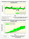
For those of you paying attention, you may have noticed the really cold week in the middle of November when often the high temperatures we saw were below the average low temperatures. Although the rest of the month was mostly average, the cold week caused the overall temperature to be 1.7 degrees below average, making it the coldest November we have seen in the area since 1996.
It was going along as a slightly drier than average month and then we got hit with 38 mm of precipitation on the 24th. This contributed to the total of 90.6 mm, above the average of 82.3 mm but still within the average range.
Of the precipitation we saw in November, 25 cm of it was snow, this is about double the average of 13 cm.
We have had 916.3 mm of total precipitation so far this year, which is higher than the average of 830.3 mm. But as well, as the average annual precipitation for the area is 904.0 mm, we are guaranteed to have more than the average precipitation for the year. However, unless we have a very wet December, the total for 2014 will probably fall within the average range.
Summary for November 2014:
Maximum Temperature 15.5°C
Minimum Temperature -15.5°C
Average Daily High Temperature 3.9°C (Long term average 5.9°C)
Average Daily Low Temperature -3.2°C (Long term average -1.6°C)
Total Precipitation 90.6 mm (Long term average 82.3 mm)
(Long term averages based on 1971-2000 data for the Waterloo Wellington Airport)


1 comment:
I remember saying "That's enough snow until about Feb, thanks", but it DID all melt :-)
Post a Comment